Search

Newsletter

XY Digitale
Critical review of studies on the representation of architecture and use of the image in science and art

THE SERIES I LIBRI DI XY

Rappresentazione antica del territorio

Giuseppina Enrica Cinque

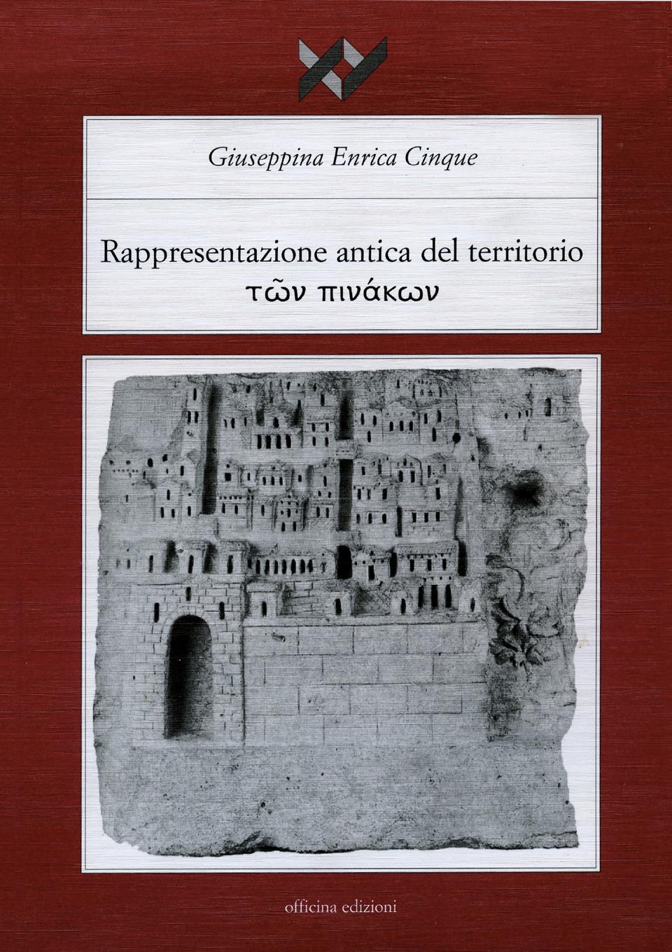
The story of drawing highlights the imponderable transition stages from depiction to representation; the moments when the graphic act corresponds to a, pursued and achieved, conscious mental power; the path that takes from the description of a real event to learning and then the drawing, abstract from reality. The history of territory representation, or portions thereof, enhances these phases: the knowledge of the territory corresponds closely to any management activity; the representation of places is an act of manifestation of power. Through the observation of phases, trials, the resulting drawings mediated by social information, the historical course allows to verify the learning and transmission processes of abstract reality; process, this, that in territory representation identifies the means by which it is possible to state the ability to dominate the sights of nature, to manage territorial portions that, in this way, become environment.
Operating a graphic abstraction, exercising power in relation to territory, already in the past caused a specific focus on what will then become science; Greeks themselves, careful assimilators of all that can be useful, invent geometry and geography lemmas directly in line with the common thread behind these sciences. Remote sources, such as cosmology, astronomy, field measurement, the topography born in the Middle East and enriched by the greek, achieve the highest exaltation of mapping when they flow into the Roman world. Seen in this way, the history of territorial iconography coincides with the history of knowledge: the analysis moves from the thresholds of epistemology and is targeted to identify practices that have created a knowledge that will take over after the name of science.

Prefazione di Adriana Soletti

INDEX

Prefazione di Adriana Soletti

Introduzione

Capitolo I

Il disegno del territorio: indicatore dell’organizzazione sociale

– Indizi e conferme nelle manifestazioni arcaiche

– Raffigurazione e rappresentazione nei territori mediorientali

– Rappresentazione del territorio tra arte e scienza nell’Egitto antico

– Rappresentazione del territorio tra arte e politica nell’Egitto ramesside e fino alla conquista alessandrina

Capitolo II

Gli approcci alla descrizione sistematica del territorio

– Modellazioni ambientali nella civiltà egea

– Descrizioni geografiche nei racconti mitologici

– Geografia, origine del disegno di mappe

– Primi tentativi per la definizione formale dell’ecumene

Capitolo III

Il territorio tra iconografia e geografia descrittiva

– Tra ermeneutica periegetica e “diórthosis”

– La geometria tra le origini mimetiche del disegno geografico

Capitolo IV

I prodromi della logica cartografica

– L’ecumene tra narrazione e applicazioni scientifiche

– Alessandro Magno. Le esplorazioni per la conquista territoriale

– La costituzione della scuola di Alessandria

– La prosecuzione della ricerca agli albori del mondo romano

Capitolo V

Le applicazioni scientifiche nel mondo romano

– L’organizzazione del territorio

– Le conquiste e il territorio

– La politica territoriale di Augusto

– Il disegno del territorio tra scaenographia, chorographia e geographia

– I contributi della letteratura scientifica e romanzesca all’indagine iconografica

Capitolo VI

Sulle tracce della cartografia sviluppata nel mondo romano e tardo antico

– Claudio Tolomeo e la scienza cartografica

– Come i geografi affollano i margini delle loro mappe

– Itinerari, origini e continuità

– La tradizione cartografica romana nel tardo antico e nel primo medioevo

Cenni in conclusione

Bibliografia

Indice dei nomi e dei luoghi

Vol: 7
Langues: Italian
Pages: 550
p-ISBN:
Year: 2002